Instructions and troubleshooting for the VertigoIMU inertial datalogger.
Born
to Engineer films from the ERAF
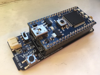
VertigoIMU Log Data Description
A compact 11dof inertial datalogger with AHRS
CSV Description
CSV log files are created on the SD card in the name format vtg_logX.csv, where X is an incrementing number. If you clear the files on the SD card, this number will reset to 0.
The CSV files contain log lines. The first column is a timestamp in milliseconds since Vertigo booted. The second column is the type of the message, which are described below.
1. GPS
Columns 3, 4, and 5 are longitude (decimal degrees), latitude (decimal degrees) and altitude (metres) respective.
Example
Message: 24508,1,-0.1435435,51.34556,123.24
Time: 24508 ms
Message type: 1 (GPS)
Longitude: -0.1435435 degrees
Latitude: 51.34556 degrees
Altitude: 123.243 metres
2. IMU (inertial measurement unit)
The fields are accelerations in x, y, z (in units of g) and gyroscope rates around x, y, z (in deg/s).
Example
Message: 24513,2,-0.018066,0.150879,1.030273,-0.792683,-0.670732,0.060976
Time: 24513 ms
Message Type: 2 (IMU)
Acceleration (x): -0.018066 g
Acceleration (y): 0.150879 g
Acceleration (z): 1.030273 g
Gyroscope (x): -0.792683 deg/s
Gyroscope (y): -0.670732 deg/s
Gyroscope (z): 0.060976 deg/s
3. AHRS (altitude and heading reference system)
Produced by the AHRS (altitude and heading reference system). The data is a quaternion in the format w, x, y, z, where w is the scalar rotational quantity and x, y and z represents a unit length vector of the quaternion that transforms the the board frame into the world (north-east-down - NED) frame.
Example
Message: 24513,3,0.951578,0.057938,0.023379,0.300992
Time: 24513 ms
Message Type: 3 (AHRS)
w: 0.951578
x: 0.057938
y: 0.023379
z: 0.300992